Tough day today. We chose to pass on the Southeastern Colorado target for better day 2 positioning. As it turned out, the southern target did produce a few tornadoes, though we have no idea how targettable they were (i.e., how well they would have satisfied the low-level wind field objective of VORTEX2, the only area of our core objectives that has remained largely unsatisfied thus far in the project). Though frustrating, the day well underscores how much we have yet to learn about tornado forecasting - why we have this project in the first place!
Further, today illustrates the myriad of choices that the investigators on this project have to face on a daily basis. As a coordinator of two observational platforms and ~20 participants, I face a number of choices over the course of a typical day. Some of these are relatively straightforward, stopping for gas or lunch, for instance. Others are more involved.
One of the more difficult choices I face is the decision to deploy StickNet probes. Though we have on occasion had multiple deployments of the same StickNet probes in a given day, we usually cannot count on that luxury. Therefore, the decision to start a deployment is not taken lightly at all. Many factors have to be considered, including the number of probes remaining, the available road network, the current quality of the target, the anticipated future of the target, the development of later targets, the amount of daylight left, the time available to make a quality deployment, hail distribution, lightning frequency, and so on. The spacing, orientation and width of deployments has to be decided on the fly.
Occasionally it is necessary to abort StickNet deployments due to safety concerns. We had such a situation back on 10 May in Central Oklahoma. A dangerous tornadic supercell thunderstorm was bearing down on the lead deployment team. [Owing to various factors, we got a late start on the lead array]. The decision had to be made to bail on the deployment. We never sacrifice safety at the cost of a dataset, no matter how good it might potentially be.
Other choices revolve around staffing, both in deployment and lodging assignments. Crew members get sick or injured, family emergencies arise, students need to get experience in new tasks, personalities conflict (on rare occasion). All of these things have to be addressed to ensure an efficient (and happy!) team. Thankfully, the TTU team works together pretty smoothly, which makes life much easier.
Back to the forecast choices made today - we will see if the decision to prioritize day 2 was the proper one. Even in the best of seasons, mistakes will be made that are only clear in hindcast. The frustrating aspects of these misses are also motivating though - we still have plenty to learn!
Monday, May 31, 2010
Sunday, May 23, 2010
Can You Find the Tornado?

A big hello to all 25 of our followers and anyone else who may be reading this! I'm always a bit unsure of what you all may be interested in reading about from VORTEX2, so I'm going to shamelessly attempt to run up my comment total by asking anyone with specific questions or suggestions for posts to let me know and I'll try my best to answer them in subsequent postings.
In the meantime, I will just share a few images the TTUKa radars have captured in the past week. The above image does have a tornado in it, which occurred to the northwest of Kingfisher, OK on May 19th, but it's not easy to tell at first glance. The image is a range-height indicator scan (which is a vertical slice through the storm) with reflectivity on the left and radial velocity on the right. The tornado is the area of lower reflectivities (green colors) near the lower center of the left panel. For this image, we were scanning the westward edge of the tornado from the south, so the winds are blowing towards the radar (cooler colors in the velocity image). The reason for the large area of orange colors within the tornado in the velocity image is that the wind speed is too high for the radar to unambiguously sample. So, once the velocity passes a certain wind speed it "folds" to the opposite end of the color scale, like Pac-Man wrapping around to the opposite side of the screen. So, backing out the actual velocity, we estimate wind speeds of upwards of 50 m/s or just over 100 mph, and we likely didn't sample the highest wind speeds in this tornado!

Ok, the second one is a bit easier, especially if you've read my last post. This image is a near-surface PPI (horizontal plane) scan taken by TTUKa-2 of a weak tornado east of Dumas, Texas on May 18th. One of the cool things about this tornado is that it did not occur in the mesocyclone, but along the rear-flank downdraft boundary (RFDB). This storm exhibited many strong circulations along the RFDB that we could watch wrap back into the mesocyclone. As circulations like this have been theorized to contribute to tornadogenesis, capturing their evolution with our radars is a very exciting finding.

Finally, this third image is not of a tornado, ... I think. This is a close-up image of the very tip of the hook of the Dumas supercell. So, when you look at a hook echo from a standard radar, the big red reflectivity ball in this image would be roughly representative of the trailing one or two pixels. All of the tip of the hook in this image is within five kilometers of the radar and TTUKa-2 was set up about 3 miles to the east, scanning the same mesocyclone. This means that we can conduct a dual-Doppler synthesis of this event and derive the full three-dimensional wind field of the near-surface mesocyclone! (this is the kind of nerdy sentence we meteorologists like to put exclamation points at the end of). So some lucky graduate student (possibly me I guess) will get to spend countless hours sorting through the fine-scale details of this case trying to make sense of it. Woohoo!
Well, we're headed to bed tonight in a state that starts with the letter "K" and should be operating again tomorrow, most likely on a road somewhere. I do want to mention that I've run the bird total up to nearly 50. Highlights include three life birds for me, a Cassin's Sparrow and Scott's Oriole just north of Carlsbad, NM, and several Clarke's Grebes in North Platte, NE yesterday.
Finally, finally, one last image, of the Kelvin-Helmholtz instability waves propagating vertically I mentioned in my last posting:

Thursday, May 20, 2010
The Dumas Day.....What a day!!

So I'm definitely a bit behind on blogging, but this day truly deserves its recognition. On Tuesday, May 18, our deployment lead us to Dumas, TX, just northwest of Amarillo, TX. This ended up being a very impressive supercell and came dangerously close to dropping a tornado over the town during rush hour.......not good at all. Luckily, only a funnel cloud was reported as it made it's monstrous treck across the middle of town, although others were reported east of town. Our deployment was relatively uneventful at first in that we didn't really have any challenges with terrain or power lines, but traffic was somewhat of an issue, given the time of day and the fact that it is a fairly major road. We did, however, struggle with the placement of our last probe as we had approached town. We aren't really able to deploy in areas like that as it presents the danger of flying debris damaging the probes, should a town be unfortunately struck. We also are not able to get the proper "exposure" to the instrument. What this means is that if there are, say, a lot of trees near a deployment, the wind speed and direction can be greatly affected by those obstacles and can skew the data actually recorded by the probe. The wind could be enhanced or hindered and thus we would not get a true sample of what actually happend within the storm as it crossed the array. This, among other things, is why we look for wide, open areas in which to stake our probes.
As for the storm, it had a very impressive structure as it crossed the array, with a large hook echo headed straight for Dumas. Large hail had already been reported from this storm at this point in time, not to mention the fact that it could have produced a tornado at any point in time as it approached Dumas. It was somewhat disturbing that during our deployment, the tornado sirens within Dumas were NOT sounding off, which worries me a bit. If the storm had dropped a tornado, it could have been even worse given the rush hour traffic and many people could have possibly been left without enough time to take adequate shelter. As we finally reached the south side of town, we found a good deployment location and dropped our last probe. Once we were finished, we basically sat there, watching and waiting to see what would happen. Luckily, no tornado was produced within town, but either way, the town was rocked with high winds and hail. As the supercell finally passed, we were able to make our way back to the north to our first probe. Thankfully, we saw no damage to anything within town, but we reached a point just north of the center of Dumas where marble sized hail covered the roadways. You could even see fog covering the fields as the hail was sublimating, or turning from a solid directly into a gas. Our first probe was unfortunately separated from us by a huge ditch full of icy hail-water......which is just as much fun as it sounds. One of my team members was able to capture a few candid shots of the pick up.....as seen above, so enjoy! The probe deployed closest to the north side of Dumas still had golfball sized hail stones and the nose cone on the propeller anemometer was broken off, not surprising given the hail. Some of the other StickNet teams were slightly more unfortunate as they encountered baseball sized hail. Let's just say that day lead to a pretty late night of fixing damaged connectors and replacing pieces of instrumentation on the probes. That's what baseball and tennis ball hail can do if caught outside.
Overall, this day was probably one of the most successful deployments so far for all of the VORTEX2 teams. Everyone was able to sample the storm from start to finish and collect very good and very valuable data. Our specific deployments were textbook and our team definitely could not have done a better job that day. It was a proud day for all researchers involved and hopefully we will be as successful in the future for the 2010 season.
Well, I guess that's all for now. After a full day of traveling, I'm kind tired ;) Until the next one....
Sarah
Wednesday, May 19, 2010
Gnarly Deployment

After rejuvenating in Lubbock and fixing instrument issues from the night before, the team was primed and ready to hit the road (05/17/2010). The morning started out with sunshine and not a cloud in the sky. One could not imagine that such a gorgeous day could produce the weather that ensued later in the afternoon.
From Reese Technology Center we departed for Muleshoe, TX to post up and get word on our target location for the day. The rest of the armada had stayed in Clovis, NM for the evening and had no plans of meeting up with us in Muleshoe. Upon arriving in Muleshoe, we were informed that we had plenty of time to kill so one of our very own recommended that we stop at a Mexican restaurant named Leal's. Most opted out of the recommendation but a group of us decided to indulge and we were not disappointed. The cuisine was delectable and I highly recommend anyone to stop by Leal's if you are passing through Muleshoe, TX.
After lunch, our target location became Vega, TX which lies west of Amarillo, TX on I-40. We did not post up in Vega long before hedging further north to Channing, TX where the entire armada parked on the side of the road. It was quite the scene watching the entire armada traverse the road together. In Channing, local and non-locals came out to investigate why we were located in their town. We embrace these interactions with locals and non-locals because it gives us the opportunity to inform them about the purpose of the our research and give them a little heads-up about the impending weather situation for the area.
After sitting in Channing for about 40 minutes, a supercelluar thunderstorm began to percolate and operations commenced! My team (StickNet 4) was instructed to bust north and east towards Dumas, TX and head north of out Dumas until further instructed. Once we arrived at our target latitude north of Dumas, we were mandated to begin deploying southward with 3 mile spacing in accordance with StickNet 2. We are always tethered to StickNet 2. They have an AED and are pretty much our lifeline when in distress.
Fortunately for Tanya and I, we did not have to take on any dangerous lightning or hail. We remained dry throughout our entire deployment. The only real challenge that we faced was determining where to deploy our StickNet probes because we try to avoid power lines and buildings that obstruct wind flow or pose as threats to our instruments. Thus, we decided to deploy in the medians.
Given that we were deploying with 3 mile spacing, we had to be mindful of StickNet 2 and their deployments because we did not want to deploy on top of them. They were instructed to deploy with 1 mile spacing and so keeping good communication was vital. Ultimately, we decided to withhold deploying our last two probes until ripping through Dumas. On the south side of town, we proceeded to drop our last two probes and then we turned around and watched our beast of a storm pass over our array. We could not have deployed any better than we did! It was a textbook operation.
Parked a few miles south of town, we watched a massive wall cloud pass through town and the inflow into the storm was incredible! Even more interesting was the exponential increase of traffic density around us. One man said that he had rushed to grab his 81 yr. old mother before the tornado reached town to get her to safety. Another couple had been traveling from South Carolina and had never been to Texas or seen a tornado before so they were flabbergasted. On the whole, it seemed that most people south of town would not dare enter town with the ominous storm approaching Dumas.
What caught my attention the most on this day besides the weather situation was a particular chaser who decided to impersonate civil service vehicles. This chaser thought that using a siren to weave through dense traffic is appropriate...THIS IS ILLEGAL! These types of chasers continue to give responsible storm chasers a negative reputation. We use rotating lights on top of our vehicles for safety purposes but we do not expect people to pull over for us nor do we try to impersonate any civil service personnel. Moreover, this reckless act clearly defines the difference between chasing and researching.
On the whole, the data set collected from yesterday's storm was probably the second best data set collected between the two phases of VORTEX2. I am sure Pat Skinner will be able to talk more about what was discovered during the radar deployments on this storm, but one of our probes (0221) recorded a max wind speed of 35.8 m/s which is roughly 80 mph. We are quite excited about this data set and are striving to collect even more research grade data sets.
Until next time..............
Tuesday, May 18, 2010
A Hilton, home, a new friend, some aliens, we do it all!
 It been another week packed with action for the V2 teams. We have officially passed the 1/3 mark of the project, and have already deployed almost as many StickNets in the past two weeks as we did for the entire season last year. That means that we're getting a lot of data, but unfortunately, many people have suffered because of the active weather season.
Since you last heard from us, we left Oklahoma, returned to Texas, operated in New Mexico, had a few nights at home, did some more operating in New Mexico. I'll try to summarize some of our outings.....after our travel day to Midland on Thursday, we operated southwest of Midland along the I-20 corridor on Friday. This was a particularly challenging day, as storm initiation began rather early in the day, and many updrafts popped up in the area. Our team saw at least one tornado to the west of Odessa, and may have seen a second, but we were not close enough to tell it if actually made contact with the ground, so we won't count it. The StickNet teams made a full deployment of probes and Ka-1 was also operating nearby. The tornado was not on the ground as it passed through the StickNet array, but funnels were spotted in the near vicinity and directly overhead.
On Saturday, we operated north of Carlsbad, NM. The supercell was a good-looking storm, coming off the higher terrain. The teams deployed on two seperate roads north of Artesia. But as the storm approached, it began dying right before our eyes, evaporating the base away. My team actually made a new friend, a friendly little dog who wondered over to investigate us. She hung around with us for about 30 minutes as we waited for further instructions. She was very nice, but seemed scared at first. I was so worried about her being next to the road, but she would follow me off of it after a while. I felt terrible leaving her there, and was wishing we were closer to home and our friend Simon, who rescues stray dogs. I would have taken her to him. At the end of the night, we treked back to Midland for the third night in a row. Which, by the way, if you're ever in Midland, the downtown Hilton is pretty nice, and they were super-accommodating for us, renting an extra parking lot across the street so we could park all the big vehicles, and made everything easy for us.
On Sunday morning, we got the word that we were going home! It was decided that it would be a travel day to Lubbock for the armada, so we bolted! We made it home around 1:00, but we had some work to do before parting ways. We washed all four trucks, both trailers, and one radar. At the same time, we had a group of people inside working on the probes, repairing connectors, loose plugs, and had Ian building a new tripod to bring 215A back to life. Half the group headed home around 3:30, and the rest followed about 2 hours later. I was responsible for running some V2 errands after dropping my laundry off at home. I took, a trailer tire to Firestone to get repaired, which unfortunately it couldn't be because we had a screw in it too close to the edge. And, because it was Sunday, they couldn't get a replacement tire for it from the warehouse until Monday, and not in time for us to get it replaced, so lucky we have a few more spares. I also had to pick up some new Texas maps for my truck and our FC truck. At home, I mowed the lawn, helped with the laundry, then met some fellow V2-ers for dinner at a hibachi grill, and then down to Broadway.
Monday, oddly enough, brought us back to New Mexico! We began by treking to Tatum, then pushed further west to Caprock, then even further so to Roswell. Roswell, if you don't know, is like the UFO/alien capital of the country. We passed the museum and many shops selling alien gear. My team was stationed on the south end of Roswell, positioned to deploy probes to the south, SN2 was stationed north of town positioned to deploy to the north. FC and SN3 moved further south, and it was almost unbelievable to watch.....they deployed on exactly the same road, and exactly the same spot as they did on Saturday. This was an incredibly tough operations day, as the majority of the armada, including our FC vehicle had little or no communications for over an hour. They had no internet, no cell phone coverage, and limited radio contact. They were unable to communicate with my team and SN2, so we remained up by Roswell for the entire event, and didn't make any deployments, but the southern two teams got a few probes in. This storm gave a hard hit to the V2 armada, as many people found themselves in ping pong and golfball sized hail. Our vehicles were undamaged, but reports indicate that 10-15 teams lost windshields yesterday. Hail is a walking advertisement for StickNets.....you don't have to sit there and get pulverized by hail to collect valuable data, and we were fortunate to have escaped with no damage.
After yesterday's event, we made the 3 hour trek back to Lubbock, while the rest of the armada hoteled further north. When we got back to our Reese facility, we had more insturments to fix, and realized that yet another Vaisala all-in-one probe was beginning to fail. It did not report any wind data, only themodynamic data. We've just about had it with these instruments. We've replaced all of them at least once, and have made many modifications to them to make them better, but they still fail. When the first group of them began failing, Vaisala claimed it was likely due to water intrusion, so we made seals and rings and used grease to make them more water tight. Strangely enough, in their next edition of the instrument, Vaisala had used many of our fixes. Again, this is a weather instrument, so how can it not work in weather?! These are meant to be placed outside, and outside gets storms! Argggg...we have shipped back the three that we have replacede in the last two weeks, so we're hopeful that they will replace them and we can pick them up on our next trip to Lubbock, whenever that may be......
We're back on the road this morning, looking to operate further to the north. If you live in the panhandle areas, make sure you're paying attention over the next few days. We'll be active....which means the weather could be severe. We're out there really trying to make a difference.
Friday, May 14, 2010
Electricity
Hi everyone! I'm sure by you've seen that VORTEX 2 has been incredibly active over the last several days. Its been a lot of long days, late nights, little sleep, no laundry, and endless fast food. I'll be honest, after the schedule we've had this week, I was so relieved when the leaders ceased operations by 5 pm last night. For only the second time this week, I made it to bed before 1 am.
Pat did a good job of summarizing our deployments over the last several days. We were incredibly active and got some good datasets on tornadic storms. And Rich has described some of the challenges and dangers of our field work. I think my mom, and probably other moms of project participants are scared of us getting blown away by a tornado. In all honesty, this is one of my lesser fears. The StickNet teams (especially the trailer teams, of which I am a member of), usually make deployments well in advance of a potential tornado, and have retreated to safety before one is even close to crossing our StickNet array. That's not to say that we're not keeping an eye out and working quickly. But my two biggest fears are traffic and lightning.
The V2 armada features something like 40 research vehicles (and that doesn't include all the media and extra vehicles that are generally with us). Add in the endless number of chasers and curious locals, and there are often over 100 vehicles on the main road, and since we will not travel down dirt roads, that means we're usually making deployments on this "main road." As a driver of one of the larger and least manueverable vehicles of the group, driving through this is nerve-racking and I'm trying to always be conscious of other people's actions (unexpected turns, changes in speed, pulling over). And I'm praying that they're looking out for me too, as I have to jump out of said vehicle and race to the back of the trailer for probe deployments.
So traffic is a problem, but lightning is even more frightening. Its so deadly and you never know when or where its going to strike. During deployments on Wednesday near the city of Sayre, OK, I called off a deployment because I felt that Rich and I would no longer be safe outside of the vehicle because of the high frequency and close proximity of lightning strikes. About 30 seconds later, our leader Chris Weiss was calling me and telling me to drop further south. What a difference those miles made. Once we retreated further south, the lightning was not nearly as active, and the threat of the approaching hail core was also diminished. After retreating several miles, we were able to safely begin our deployments again. And one of our probes was deployed within a few hundred yards of an FCMP (Florida Coastal Monitoring Project) disdrometer probe, and a CSWR (Center for Severe Weather Research) tornado pod. The mobile mesonet vehicles were also active on this road, and I saw several radars scanning as well, so a good, coordinated deployment was pulled off once again.
Despite the wild ride that night, all edition 2 probes (the probes that come out of my trailer) functioned fully, and there were just minor issues with the probes (connectors and switches to tighten). Trailer 1 had a Vaisala all-in-one sensor fail (for some reason these seem to fail frequently in heavy rain....its amazing to me that a weather instrument can't take some weather!!! What are these things supposed to be used for anyway!), but thanks to Brian and Ian, the sensor was replaced and the probe is operational again. By about 1 am on Thursday morning, we were ready for the next day's deployments.
Well, its about that time, to begin loading the luggage and getting the trucks ready for departure, to get back after it today. We'll let you know what we find....
Thursday, May 13, 2010
Mmmmmmmm Donuts
 A big hello to all 19 of our followers and anyone else who may be reading this! So, it's been a long three days since my last post and an awful lot has happened, I'll try to catch everyone up.
I'll start with the most exciting news for our TTUKa teams. We managed to scan a developing tornado just southwest of Clinton, OK last night around sunset. The image above shows the reflectivity image of the tornado as observed by TTUKa-1, it is the "donut" in the lower-left portion of the image. We were at a range of about 18 km to the tornado, which is quite a ways farther than we'd like to be, but it's exciting that we were still able to capture structure this detailed at long range. Also, and from our perspective this is as exciting as the tornado, we captured several RHI (range-height indicator) scans (which look at the vertical structure of the storm rather than the horizontal) across the rear-flank downdraft boundary of the Clinton supercell prior to tornadogenesis. These scans revealed horizontal circulations in the strong convergence at the interface of the downdraft and storm inflow. A series of these circulations propagated vertically within the upraft and the level of detail captured has us all very excited! (Hopefully I can get a screen capture or two of these up in a future posting, I don't think I have done them justice with my description)
Our Tuesday deployment was pretty hectic as storm motion didn't cooperate with our forecast (it hasn't yet this year, so we're getting better at adapting) and we didn't get on the storm until nearly sunset. Still, we were able to capture the first-ever coordinated Ka-band dual-Doppler dataset with our sister radar TTUKa-2! Now, next time we collect dual-Doppler data with the TTUKa's, we'd like to be scanning a non-elevated supercell, preferably tornadic (in open country), and at an elevation angle less than 5 degrees. But still, it's a start.
As Rich has described below, Monday was a tough and sobering day for most of the V2 participants and our thoughts remain with the families effected by the tornadoes in Oklahoma. Driving through the tornado damage north of Seminole was a poignant reminder of why we do what we do. Hopefully we will do it well enough to make a difference in a few lives effected by tornadoes in the future.
Operationally, Monday was as difficult as it gets. Low visibility due to both terrain and low clouds coupled with very fast storm motion and backbuilding storms all combined to make for very challenging and dangerous deployment conditions. The whole V2 armada performed admirably under the conditions and we were fortunate to collect some good data on the Norman/Tecumpseh/Seminole tornado. The radars got a couple of deployments in, but terrain and precipitation-filled RFDs prevented any scans of the tornado from being obtained.
It's looking like operations are unlikely today in a region roughly bounded by Siberia, the central Indian Ocean, Patagonia, and the Aleutian Islands, but we'll probably be back to work tomorrow. I'll let you know how it goes!
p.s. Way to busy to bird the last few days, but I have managed to run the project total up to 39 species, including a Dick Cissel while scouting locations near Stillwater, OK.
Tuesday, May 11, 2010
Back-To-Back Deployments

Hello Fellow Followers,
I have finally managed to get around to blogging. My name is Rich Krupar and I am still in the process of finishing my first year of graduate school at Texas Tech University. Before leaving for VORTEX2, I had to re-schedule a statistics final exam that I must take when I return from the field project. Let me tell you, this is a royal pain! There was so much paper work involved to get the incomplete approved. Signatures from the dean of the math department and the graduate school were required and a contract was established between my professor and I. Nonetheless, I managed to get everything sorted out and now the honus is now on me to prepare for the exam. No sweat right? I mean, I get more time than anyone else in the course to prepare for the exam so I should ace it in theory. Theory is always susceptible to change.
A lot has been going on since our first deployment on May 10th, 2010 and today warrants a discussion of the events that have unfolded. As most of you are aware, May 10th, 2010 was a very scary day for residents in Oklahoma. Rapid storm motion of 50-60 mph and vigorous tornadoes wreaked havoc in many parts of Oklahoma including Norman and Seminole. This was a challenging day for our teams because we could barely keep up with the storms and make pertinent deployments of our StickNet probes. It was my first time deploying in a storm environment and it sure was challenging. My teammate Tanya and I worked efficiently enough to get two probes down but could not manage to deploy anymore because of extensive foliage and dangerous storm motion. In an attempt to catch a tornadic storm south near Seminole, OK, my team made a maneuver south but was alerted quickly by our Field Coordinator (FC) that the situation was too dangerous for us to pursue. We followed orders and made our way south once the tornadic storm passed. To our surprise, we saw the damage that Seminole had experienced. Damage to family residences and mobile homes was evident, along with snapped trees and downed power lines. Pictures are to follow but we as a group would like to provide a disclaimer about our photos: damage photos were taken for research purposes and we in no manner meant to offend those who were traumatized by the loss of property. We are striving to make scientific leaps in our respective field and we want to save as many lives as we can. We are not storm chasing...we are advancing our scientific knowledge.
This was the first time I have seen tornado damage in person following a tornado event and it was quite a humbly experience. If there ever was a lack of motivation to execute the purpose of our project, the Seminole event provide even more impetus to advance lead times on tornado warnings and further our knowledge about tornadogenesis (the beginning stage of tornadoes). Our hearts and prayers go out to those who were affected by the tumultuous weather.
That same night, our group lodged in Shawnee, OK where the we had no power at our hotel because of the severe weather. We had to use flashlights and candles to make it up the stairs to our rooms and showers were lukewarm at best. Despite the lack of power, we were thankful to have a roof over our heads for the night. Local residents impacted by the day's events were lodging with us because they could not remain in their damaged residences. May 10th, on the whole, lended light on how precious life is and how we all should not take it for granted or underestimate the power of mother nature.
May 11th, 2010 provided us with another day of research in western Oklahoma. We managed to lay down our entire array of StickNets but the target storm of interest never seemed to turn right enough to make contact with our probes. I felt a lot more comfortable deploying this time around and it seemed like Tanya and I had acquired a great line of communication that allowed us to deploy rapidly.
As dangerous as deployments can be, pickup can be just as dangerous, if not more dangerous. The night sky obstructs our view, making it difficult to retrieve the probes. We heavily rely on the map markings that our navigator makes on our DeLorme map software to estimate our pickup location. Oncoming traffic also poses another threat to life as we pick up our probes. Extreme caution is exercised always during both deployment and retrieval.
With many weeks left in the project, I am confident that more deployments will take place and more interesting stories will be told. Stay tuned...
Sunday, May 9, 2010
Home Sweet Home!
 A big hello to all 16 of our followers and anyone else who is reading this! TTUKa-1 (the better-looking radar in the picture above) is back on the road after an unexpected, but welcome trip back to Lubbock. With operations down for Friday and Saturday and the rest of the V2 armada staying in Amarillo, the TTU teams opted out of the hotel to get a couple of nights in our own beds. The break also coincided with a celebration of the 40th anniversary of the Texas Tech Wind Science and Engineering Department, so we were thrilled to be able to make it back for the party and show off all of our instrumentation for the alumni in town for the event.
 Prior to the brief trip home, we did get to deploy for the first time in 2010 on an elevated supercell in northwestern Kansas last Thursday. The supercell did not offer much for satisfying research objectives as there was virtually zero chance of it becoming tornadic, but it did offer a great, low-stress deployment to shake off the rust from last season. It was especially nice to get a chance to attempt a coordinated deployment with TTUKa1 and TTUKa2 before we're out on the real deal (which starts tomorrow) to iron out any communications problems.
So, between the "practice" deployment last Thursday and the weekend at home, the TTU teams are well rested, ready, and eager for some tornadic supercells in unpopulated areas to collect data on. And it looks like Mother Nature will oblige us. A deep trough in the southwestern U.S. looks likely to create a severe weather outbreak tomorrow somewhere in central North America, and opportunities for V2 deployments will likely persist through at least Wednesday. So the next time I blog, hopefully I'll have multiple successful deployments to discuss!
Finally, I'm reasonably sure this is of interest to around 0% of you, but it's my blog so I'm including it anyways. One of the challenges of severe thunderstorm field work is finding hobbies to occupy long hours of down time on the road. Over the years, this has led to me becoming a fairly avid birdwatcher. So I'll be using the final paragraph of my postings to update you, the readers, on my progress towards seeing 75 species of bird over the course of V2. Currently, I've picked off most of the likely roadside bird suspects while driving, and have 32 species seen. I'll have to find some opportunities to bird in some better habitat (and not while moving 70 mph) in the upcoming weeks if I'm going to reach the goal.
Wednesday, May 5, 2010
StickNets

Since it doesn't seem likely that we will be doing any operating today, I thought I would take some time to explain some of our instrumentation. Chris has already mentioned that the Texas Tech suite of instruments includes 24 StickNet probes and 2 Ka-band mobile radars. I'll describe the StickNets in a little more detail, and describe our typical operations plan for deploying them. I'll leave the Ka radar descriptions for Pat....
As Chris mentioned, the StickNets are a rapidly deployable surface observing platform. They all feature two primary parts--an extendable tripod (like the kind surveyors use) and a data aquisition (DAQ) box. All StickNets measure wind speed and direction, temperature, relative humidity, and pressure. They all feature a flux-gate compass so that we don't have to worry about orienting them towards a particular direction when we make the deployments. Beyond that, there are some differences. We have two instrument configurations. The first, called an "A" probe features a standard propeller anemometer to capture the wind data, which is mounted on the top of the tripod, a temp/RH sensor (instrument that measures, you guessed it, temperature and relative humidity) that is mounted on the DAQ box, and a barometric pressure sensor located inside the DAQ box. The second configuration, called the "B" probes features an "all-in-one" sensor, meaning that wind speed and direction, temperature, and relative humidity are all collected by one sensor. In additon this sensor can measure precipitation type (hail vs. rain) and can estimate the quantity. This sensor is mounted on the top of the tripod.
It takes 2 people 2 minutes or less to deploy a StickNet. I'll give you a play-by-play of a deployment in my vehicle.....when we pull up to a deployment site, my partner (fellow blogger Rich) and I jump out of the truck and race back to the trailer. After opening the trailer and securing the doors, I will hop in and unhook a tripod. I will jump out of the trailer and head for the deployment site, calling out the probe number to Rich. He will grab the DAQ box, and run out to meet me. By the time he gets there, I have usually extended one of the three tripod legs, and he will set the DAQ box down and together we will work on the last two legs. Then we will take a moment to ensure the probe is level. Then he will lift the DAQ box into place, while I secure it with a pin. I will then power the probe on, hook up the two connectors to power the GPS and instrumentation and turn the data switch on. The software will run a series of tests and once the data light stops blinking, I know the instruments are ready to sample. While I am working on the hookup, Rich is responsible for driving a stake through each of the three tripod legs to secure the probe into position. We generally finish our tasks at roughly the same time, but whoever finishes first runs back to the trailer to close up the doors. We hop into the truck and drive off to the next deployment location. We also have a third member of our team who remains in the truck. He is responsible for keeping a log of all of the deployments, marking the time, GPS coordinates, any obstructions, and any notes that may come in handy. He can also monitor the radio traffic and internet chat to ensure we don't miss any important messages, and also acts as a spotter, keeping an eye on us as we deploy outside of the truck.
Seems like a lot, but yes, we can do it in under 2 minutes and by the end of the season when we've had a lot of practice, we can get much closer to the 1 minute mark!
Before we begin the deployments, Chris instructs us which road we will be using, and what spacing we should allow between the probes. We do our best to keep to the spacing he instructs, but sometimes towns, trees, buildings, etc., get in the way, so we do the best we can. My truck, pulling a trailer, handles one of the two coarse array deployments. Our probes are generally spaced 1-2 miles apart. As the storm gets closer to the deployment road, the non-trailered trucks (which are much more maneuverable) lay down a fine-scale array, centered near where they think a potential tornado or mesocyclone could cross the road.
I included a picture that Kristina Butler took of Brian Hirth and I doing a mock deployment during local media day. He is getting ready to move the DAQ box into place and I am standing by to secure it with the pin. Even after a year of off-time, we finished the deployment pretty quickly! The StickNets are really remarkable. They were designed and built and are maintained entirely by TTU students. Not only are they rapidly-deployable, but because they are unmanned, they can be placed into parts of the storm that you would not want to send people or vehicles! We can deploy them in plenty of time to retreat to safety.
Tuesday, May 4, 2010
Catching up....
Well, the new GPS instruments arrived in Lubbock today, so now the 3 of us who stayed back are finally getting to meet up with the rest of the crew! I'll admit I've been getting pretty stir crazy lately and just really needed to get out of town! Whew! Although, from all I've heard so far, the teams are pretty much just hanging out in Oklahoma, waiting and waiting. At least it will be nice to get back with everyone and stay up-to-date on what's going on. Hopefully we'll have something more interesting to write about next time :)
Later!!
Sarah
Later!!
Sarah
Monday, May 3, 2010
Greetings all! My name is Christopher Weiss, an Assistant Professor of Atmospheric Science at Texas Tech University, and one of the Principal Investigators for the VORTEX2 Project. I have a great crew of ~20 faculty, staff and students behind me out here in the field, many of which you have already heard from in previous posts.
We have science objectives that look to be satisfied with the wealth of instrumentation available in VORTEX2. Texas Tech, specifically, has two primary platforms. The first of these is dubbed "StickNet", and array of 24 in situ observation probes, which are deployed in the path of supercell thunderstorms, hopefully capturing key thermodynamic and kinematic gradients in the immediate vicinity of developing tornadoes. Texas Tech also boasts two high-frequency mobile Doppler radars - the TTUKa radars - which are charged with the remote sensing of tornado structure from a distance of about 1.5-2 km ideally. These radars feature a particularly narrow beam, about half degree wide, which allows for resolute data collection very close to the ground, where scientists believe some of the keys to tornado genesis, maintenance and destructive potential are located.
One of my main responsibilities for the field phase of the project is related to the coordination of the instruments. Specifically, I am tasked with aligning the four StickNet vehicles in such a manner to deploy our complement of probes in a safe and efficient manner. The operations plan calls for a lead time of ~60 minutes to run the entire deployment properly. Often, owing to uncertainty in the evolution of the storm or poor road networks, we have a little less time than desired, but still manage to gather scientifically meaningful data safely. The task can be stressful at times, but I find it helpful to draw on past experience in the field (this season is my 12th consecutive).
Another of my responsibilities is to look after the general well being of the crew. In a seven-week project like this, there are bound to be a few illnesses and minor injuries. Beyond physical ailments, though, this type of time commitment comes with a wealth of peaks and valleys in team morale. Though I am far from a cheerleader, I feel it is important to keep the team focused through those rough periods.
We just hit the road today and are currently sitting in northwest Oklahoma for the evening. We do not anticipate a particularly active start to this second year of VORTEX2. Perhaps conditions will slowly improve through the next few days. Many of us actually prefer this type of start - there is a fair amount of spin up necessary to be effective once the real storm intercept opportunities appear later.
Certainly will be more later - I will try to share some of the successes and struggles we encounter through the season.
Sunday, May 2, 2010
Hi everyone! I haven't had the chance to write a blog yet, but here I am finally! I am Sarah Dillingham, a second year Masters student at Texas Tech University. I will be graduating in Fall 2010 with my Masters in Atmospheric Science, and will continue my new job as a broadcast meteorologist for a local station here in Lubbock. I've had a passion for weather my entire life, and I am so excited to be living my dream and doing severe storms research. My meteorological career started at the University of Georgia, where I earned a B.S. in Geography and Atmospheric Science and I have learned a great deal over the past 8 years I've been in college! VORTEX2 is one of the greatest things I may ever have the chance to be apart of, and I hope that our work with the TTU Teams will continue to help further the science.
As I'm sure you've already read from Tanya's blog, Mother Nature is still not ready to give up her secrets for at least a couple more days. With the only viable targets for today and tomorrow being marginal, at best, the powers that be of V2 have decided to forgo operations for today. However, we will be departing tomorrow for sure to begin our now 6 1/2 week journey through the Plains. I'm sure many of you are aware of the GPS issues a few of our teams are facing now, but those new instruments should be coming in on Tuesday morning. I am electing to stay behind and get them, if Dr. Weiss approves :) because I am still working on a proposal for one of my classes. Yes, that's right. I still have some classes that are not yet concluded, so I will not truly be able to enjoy myself for another couple of days......but oh well. I'm just really ready to get out of town, and VORTEX2 is a great way to do that....obviously. This has been a long and difficult semester, and I NEED A VACATION! Haha! Even though I will be doing quite a bit of physical labor during the project, it's a different kind of stress and a version of it that I can handle :) I will be a deployer with StickNet Team 2 this year, and our team will be responsible for deploying the fine scale arrays of instruments, up-close and personal with the supercells! I'm a bit nervous in this particular position as I will be working with one of the veterans of the TTU team, Ph.D. candidate Brian Hirth. Hopefully I'll be fast enough...... ;)
Like many other participants in our group, this will be my last field research project. I am really looking forward to this project again because I learned SO much last year and am anxious to see what the weather has in store for us this season. As we are beginning to transition out of El Nino, we may have an interesting project ahead of us. But only time will tell. Either way, let's hope that if and when the weather gods decide to release their fury again, our teams will all be there to capture it and collect some valuable data. My heart goes out to those who have already been affected by the events over the past two weeks, and hopefully our research will teach us more about tornadoes and other related severe weather events. While we will not be able to stop how the atmosphere behaves, we can surely help you and your families keep yourselves as safe as possible, should you ever be affected by any events.
I guess that's all I have for my first post, but now I guess I better get back to that proposal..... ;) Talk to you all again soon!
Sarah
Two extra days at home


We just got the word that we are down again today. However, we have received confirmation that we WILL be leaving tomorrow. It may be to operate, or just to meet up with the V2 armada, whereever that may be. Pat did a great job of explaining exactly why it is we haven't jumped after the mess of storms off to the east. Those locations are out of the domain for a reason. And our goal is to collect meaningful data, and if we can't do that, there is no point in operating there.
After our tiring week, I think we all enjoyed having yesterday off. I wanted to share with you some photos from my backyard. Last year I was heartbroken that my flowers didn't bloom until after we had begun V2. This year I was lucky enough to get to see them! I have 6 blooming irises and several more that should bloom soon. And my rose bush is full of blooms. An extra day at home made the difference for me!
Other than that, I enjoyed eating lunch at a new pizza restaurant with Ian and my fellow blogger and roommate Sarah. Then had a nice nap with my two beagles. Then a nice "family dinner" of fried fish and corn and potatoes with Ian, Pat, Sarah, Scott, Brian, and Allison. Today....I think we're catching a Tech baseball game!
Saturday, May 1, 2010
And We're Off!!
 A big hello to all six of our followers and anyone who is reading this! As you can see from the above image featuring fellow Texas Tech V2 participants Sarah Dillingham and soon to be Dr. Ian Giammanco, we have had an uneventful first day of the project. That does not mean it has been an uneventful weather day as severe thunderstorms and tornadoes have unfortunately effected portions of Arkansas, Mississippi, and Tennessee. Our hearts go out to everyone effected by today's weather and it's natural to wonder why VORTEX2 wasn't out to collect data on these storms. The first reason is purely practical, it wasn't logistically possible to get from Lubbock, Texas to eastern Arkansas in a single day to be in the proper position. The second reason requires that we draw a distinction between simply seeing tornadoes and collecting meaningful data on tornadoes, which also lends itself to a discussion on the role of the TTUKa mobile Doppler radars that I will be working with this year. I'll try to outline the distinction below:
One of the primary research thrusts of the "tornado-scale" radars participating in V2, which consist of the two TTU Ka-band radars, the Rapid-Scan Doppler on Wheels, and the UMASS W-Band radar, is to collect multiple-Doppler datasets of tornadoes (and hopefully tornadogenesis) very near the ground. This region, known as the "corner-flow" region is where strong inflow into the vortex is tilted into the vertical to ascend within the tornado. Very few observations have been made of the corner-flow region and to the best of my knowledge, no dual-Doppler datasets of the region exist. As the majority of people inhabit the same near-ground region, a better understanding of the corner-flow region will hopefully lead to a better understanding of how tornadoes produce damage and to safer building designs.
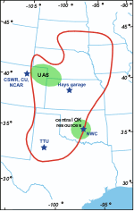
That said, there is a reason very few datasets of the low-level tornado vortex structure exist. In order to obtain the desired measurements, multiple high-resolution Doppler radars need to be properly placed in positions very close to the tornado with nothing obstructing their view such as trees, buildings, or terrain features, and they also need to have little or no precipitation falling between their position and the tornado. The reason for these requirements involves the tradeoffs necessary to make when designing a Doppler radar. The tornado-scale radars have sacrificed the ability to scan over long distances and through heavy precipitation in order to have very high spatial resolution and a greater sensitivity to make accurate velocity measurements. Therefore, to maximize our chances of getting an unobstructed view of the tornado with the Doppler radars (and to keep wind measurements from surface observing equipment such as StickNet from being influenced by vegetation and terrain) V2 will primarily target storms that form in very flat regions with few trees (http://www.eol.ucar.edu/projects/vortex2/images/v2_domain_70dpi.gif).
It's a pretty tall order to get an unprecedented dataset, but we should get several chances over the coming weeks and hopefully we can nail a few events. I'll be here to post the summary once we do!
Subscribe to:
Posts (Atom)